At a Glance
The shape of the event
- Date
- c. 900 CE
- Place
- East African coast
- Type
- Urban and commercial expansion
A network of port towns became visible from Somalia to Mozambique, with local elites using trade, Islam, architecture, and language to build authority.
The rise of the Swahili Coast makes East Africa part of Indian Ocean history before European arrival and gives the atlas a stronger maritime Africa route.
Follow the next entries to trace the material and human routes that made the Swahili coast more than a string of ports.
Background
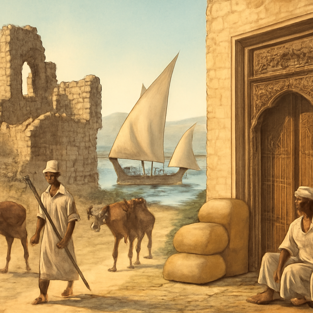
Long before a single coral mosque crowned its skyline, the stretch of coastline from Somalia down to Mozambique was a place of connected lives: fishermen casting nets, caravan routes threading inland, and communities familiar with exchange across water. The Indian Ocean had long carried goods, ideas and people; crucially, the seasonal monsoon winds made predictable, repeatable voyages possible. By the ninth century, Swahili-speaking merchant communities occupied strategic sites—sheltered bays, river mouths and reef-fringed harbors—that invited outsiders and offered access to hinterland products such as ivory, timber, and agricultural surplus. The spread of Islam among some merchant circles linked parts of the coast to wider Muslim commercial networks without erasing local customs.
Architectural choices—shifting from wood to coral stone—reflected both practical responses to climate and a desire to signal permanence and status. None of these pressures acted alone: the rise of coastal towns was the result of overlapping economic opportunity, maritime technology, religious connections and local choices about urban life and authority. The Swahili Coast city-states should begin with African coastal agency. Towns such as Kilwa, Mombasa, Pate, and others grew through fishing, farming, craft production, local authority, Islam, and monsoon trade. Indian Ocean connections mattered, but they did not create passive ports. Coastal communities actively shaped language, architecture, kinship, diplomacy, and commercial rules. The rise of these cities also complicates the boundary between local and global history.
Coral-stone mosques, imported ceramics, coins, houses, oral memory, and archaeology show places that were both deeply East African and visibly connected to Arabia, Persia, India, and beyond.
The Turning Point
Around c. 900 CE a recognizable shift occurred: dispersed villages consolidated into urbanized port towns that coordinated long-distance trade and local governance. Swahili merchant communities made conscious choices about where to anchor seasonal trade—selecting sites with deep-water access or defensible positions—and invested labor and resources in building permanent structures from coral rag and lime. Muslim merchants arriving from Arabia, Persia and beyond found reliable partners on the coast; shared religious practices eased credit-making, dispute resolution and reciprocal hospitality, increasing the volume and regularity of commerce. Monsoon sailing patterns turned sporadic contact into predictable circuits, enabling larger-scale import and export and encouraging specialization.
Inland producers and traders reoriented routes to reach these emerging hubs, creating a two-way flow of goods and information. Local elites—sometimes merchant families, sometimes town councils—used trade revenues and visible architecture to claim authority, embedding new polities in the rhythms of the Indian Ocean. The result was not a single revolution but a series of concrete decisions by people who chose to urbanize, to network, and to present themselves as stakeholders in a maritime system. The turning point was the growth of durable urban networks along the coast. Seasonal winds, harbor knowledge, mainland routes, and Islamic institutions allowed city elites and merchant families to turn location into authority.
Consequences
In the near term, the visible consequence was a string of functioning port towns stretching from Somalia to Mozambique. These centers hosted markets where African products met Asian and Arabian goods; they attracted artisans, clerics, ship captains and interpreters, and they created new social roles tied to seaborne commerce. Over decades, the adoption of Islam by many coastal elites and merchants created cultural and legal links that facilitated further exchange without erasing local languages and customs. Architecturally, coral-stone mosques, houses and tombs signalled permanence and ambition, altering coastal landscapes and local memory.
In the long term, this expansion rewrote East Africa’s place in regional history: instead of being seen only through inland developments, the coast became integral to Indian Ocean narratives. The Swahili towns became nodes in maritime networks whose rhythms would endure and change under later pressures—new states, differing trade patterns and, eventually, European intrusion. Importantly, later states and movements would remember and rework this period, projecting back ideals of authority, piety and cosmopolitanism onto the earlier city-state era. Reading the rise of the Swahili coast with attention to both immediate choices and deeper causes helps avoid flattening it into a single dramatic date and shows how many communities experienced and shaped these transformations.
The later story runs through Kilwa's wealth, Ibn Battuta's descriptions, Portuguese attacks, Omani influence, Zanzibar, and modern Swahili identity. The page should prepare readers to see the coast as a long-lived system rather than a prelude to European arrival.
Interpretation Notes
Swahili Coast City-States Rise is easy to flatten into one dramatic date. A stronger reading separates immediate action from deeper causes, affected communities, and the memory later states or movements built around the event.
Why Keep Reading
Follow the next entries to trace the material and human routes that made the Swahili coast more than a string of ports. Look for accounts of specific towns—how they negotiated inland trade, how coral-stone construction altered urban life, and how shifting monsoon patterns and larger Indian Ocean politics affected everyday people. Each connected event deepens the picture: trade networks reveal economic lifeways, religious links show cultural exchange, and local political changes explain how authority was built and contested along the shore. Read the Swahili Coast with Kilwa, Ibn Battuta, Portuguese capture of Kilwa, Zanzibar, and the Indian Ocean timeline to follow how port cities connect inland, ocean, and religious worlds.
Reading Path
Follow the story without losing the thread
Before This
- House of Wisdom Flourishesc. 830 CE
- Baghdad Founded762 CE
- Abbasid Revolution750 CE
After This
- Fatimid Cairo Founded969 CE
- Chola Raid on Srivijaya1025 CE
- Great Zimbabwe Risesc. 1100 CE
Same Period
- Chola Raid on Srivijaya1025 CE
- Kilwa Sultanate Flourishesc. 1200 CE
- Ibn Battuta Visits Kilwa1331 CE
Wider Timeline
Mind Map
How to think about Swahili Coast City-States Rise
Monsoon winds
Seasonal winds that made predictable Indian Ocean voyages possible and encouraged regular trade circuits
Map Layer
Where this event sits geographically
Gold pins mark the approximate locations of published event pages. This is a schematic locator map, not a historical border map.
Coordinates are approximate and are used to help readers orient themselves before opening a full event page.
References
Where to Check the Facts
- Encyclopaedia Britannica: KilwaReference for Kilwa as a Swahili city-state, commercial center, Portuguese occupation, and later decline.
- Official UNESCO World Heritage Centre: Ruins of Kilwa Kisiwani and Songo MnaraReference for the material remains and Indian Ocean setting of Kilwa and Songo Mnara.
- The Metropolitan Museum of Art: Trade and Travel in the Islamic WorldReference for Indian Ocean routes, travel, and exchange.