At a Glance
The shape of the event
- Date
- 1885 CE
- Place
- Dar es Salaam
- Type
- Colonial rule
A German colony took shape across much of present-day Tanzania, Rwanda, and Burundi under violent and extractive administration.
The event gives East Africa a colonial frame that links Berlin-era diplomacy to local resistance, forced labor, and later nationalist memory.
Follow the threads from this foundation to see how treaties and conquest translated into everyday rule, how communities adapted or resisted, and how imperial choices shaped later politics.
Background
The late nineteenth century saw European states rush to claim African territories, a process historians call the Scramble for Africa. That pressure arrived in East Africa as competing coastal claims, commercial ventures run by chartered companies, and a growing appetite for overseas prestige. In practice, imperial expansion combined diplomatic bargaining in European capitals with on-the-ground strategies: treaty-making with local leaders, the use of force where agreement could not be secured, and the projection of authority inward from coastal entrepôts. Chartered companies and individual agents sought land, trade monopolies and administration; metropolitan governments often followed or formalised these initiatives. Local polities and communities encountered these pressures unevenly — some negotiated new arrangements, others resisted incursions into territory, labour and governance.
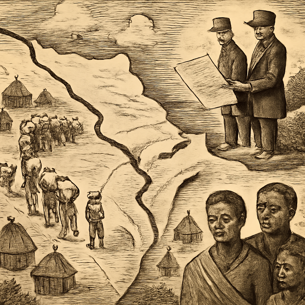
The international context — rivalries among European powers and the conventions of Berlin-era diplomacy — set the stage for turning coastal footholds into formal colonies. The colony began through a mixture of paperwork and coercion. Carl Peters and the German East Africa Company used treaties that often rested on unequal translation and pressure, while Bismarck's government converted private claims into imperial protection. Coastal cities, caravan routes, plantation ambitions, and European rivalry all shaped what Berlin called legal acquisition and what many East African communities experienced as intrusion.
The Turning Point
The establishment of German East Africa in 1885 marks the moment when scattered elements — coastal claims, company ambition, treaties and compulsion — began to cohere into a sustained colonial project. In Dar es Salaam and its hinterland German agents and companies pushed inland, converting diplomatic recognition and signed agreements into administrative structures and military presence. Carl Peters appears in the record as a prominent agent associated with that expansion: his activities exemplify how individual initiative and metropolitan support combined to secure territory. For East African communities the change was concrete: legal instruments and new officials redefined authority over land, taxation and labour.
Decisions taken then — to rely on chartered companies, to enforce treaty obligations, to back conquest with force — redirected power from many local centres to a colonial administration determined by extraction and control. What had been a set of rival claims became a political order claiming jurisdiction across much of the region. The shift from company claim to colonial rule turned ambiguous agreements into armed administration. Once German authority was backed by soldiers, courts, taxation, and labor demands, resistance became a question of survival as well as politics. The coastal revolt and later conflicts showed that local communities understood the stakes quickly: colonial paperwork would be enforced by violence if challenged.
Consequences
In the near term the formation of a German colony remade political geography: a single colonial administration began to govern broadly across territories that correspond to large parts of present-day Tanzania, Rwanda and Burundi. That administration employed policies of coercion and extraction — including forced labour and demands on local production — that altered rural economies and social relations. Resistance followed in multiple forms, from negotiation and accommodation to armed opposition; those responses shaped both how the colony operated and how it was remembered. Over the longue durée the colonial frame established in 1885 mattered for politics and memory. Berlin-era diplomacy and the systems created on the ground informed later mandates, territorial adjustments and nationalist narratives.
The imprint of colonial administration — its legal categories, land dispossession, and labour regimes — persisted into postcolonial state-making and collective memory, creating linkages between imperial decisions in the 1880s and twentieth-century struggles for sovereignty and social justice. German East Africa became a laboratory of extraction, forced labor, and punitive rule, culminating in crises such as the Maji Maji rebellion. Its later transfer into mandates after World War I did not erase the earlier structures. Borders, labor systems, and memories of violence continued to shape Tanzania, Rwanda, Burundi, and wider debates over colonial responsibility.
Interpretation Notes
German East Africa Established is easy to flatten into one dramatic date. A stronger reading separates immediate action from deeper causes, affected communities, and the memory later states or movements built around the event.
Why Keep Reading
Follow the threads from this foundation to see how treaties and conquest translated into everyday rule, how communities adapted or resisted, and how imperial choices shaped later politics. Read on to trace the administration’s consolidation inland, the forms of resistance that emerged in response, and the ways German colonial structures were reorganised or inherited under later mandates and national governments. Understanding this sequence illuminates why certain borders, economic patterns and historical memories took the shapes they did, and why the 1885 moment continues to matter in East Africa’s histories. Read this before the Maji Maji rebellion and African decolonization routes.
The next pages show how colonial authority moved from chartered claims to daily coercion, and how communities answered that power through revolt, adaptation, and later nationalist memory. A useful source lens is to treat treaties as contested objects. German agents presented documents as consent, while many East African communities faced language gaps, coercion, and later armed enforcement. The paper trail matters because it shows how imperial legality was manufactured before colonial violence made it practical.
Reading Path
Follow the story without losing the thread
Before This
- Berlin Conference1884-1885
- Indian Rebellion of 18571857-1858 CE
- Tupac Amaru II Rebellion1780-1781
After This
- Battle of AdwaMarch 1, 1896
- Maji Maji Rebellion1905-1907 CE
Same Period
- Columbus's First Atlantic Voyage1492 CE
- Fall of the Aztec Empire1521 CE
- Berlin Conference1884-1885
Wider Timeline
Mind Map
How to think about German East Africa Established
Scramble for Africa
European diplomatic rivalry created incentives for rapid territorial claims along the East African coast and hinterland.
Map Layer
Where this event sits geographically
Gold pins mark the approximate locations of published event pages. This is a schematic locator map, not a historical border map.
Coordinates are approximate and are used to help readers orient themselves before opening a full event page.
References
Where to Check the Facts
- Encyclopaedia Britannica: German East AfricaReference for the colony's formation, geography, and German rule.
- Encyclopaedia Britannica: Berlin ConferenceReference for the wider Scramble for Africa diplomatic context.
- Library of Congress: U.S. History Primary Source TimelinePrimary-source timeline reference for Atlantic settlement, colonial expansion, reform, and later U.S. history routes.