How to Read the Year
Why does 1200 CE make medieval maritime power visible beyond Europe?
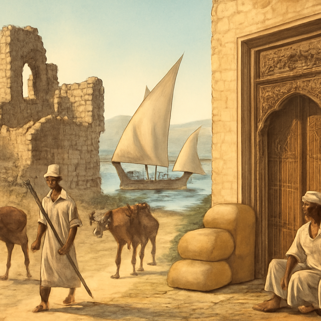
1200 CE connects Kilwa's Swahili commercial power with Tongan maritime chiefly expansion. The pairing works because both stories make political authority depend on water. Kilwa mediated gold, ivory, ceramics, cloth, Islamic prestige, and Indian Ocean contacts. Tonga projected chiefly power through voyaging, tribute, kinship, ritual authority, and central Pacific connections.
The year resists a narrow medieval map. Instead of beginning with European castles or crusader states, it asks readers to follow dhows, monsoon routes, coral-stone towns, canoe voyaging, island networks, chiefs, merchants, and sacred legitimacy. These worlds had different institutions, but both show how distance can become governable when people know routes, seasons, hosts, and obligations.
A richer reading also separates evidence types. Kilwa can be approached through archaeology, architecture, coins, ceramics, later travel writing, and coastal histories. Tonga requires attention to oral tradition, genealogy, archaeology, settlement patterns, and regional memory. The page gains authority when it names those source families instead of pretending every medieval society left the same archive.
The Swahili side of the year is about more than trade volume. Coral-stone architecture, Islam, elite households, imported ceramics, gold routes from the interior, and port diplomacy all made Kilwa a political community as well as a market. The city mattered because it could translate inland wealth into oceanic relationships, urban prestige, and regional authority.
The Pacific side keeps another model of scale in view. Tongan authority moved through kinship, chiefly status, voyaging knowledge, tribute relationships, marriage ties, and ritual geography. That history helps readers see an ocean as connective infrastructure: canoes, stars, winds, reefs, stories, obligations, and remembered routes made distance readable.
Monsoon and navigation knowledge connect the two cases without making them identical. Kilwa's dhow routes and Tonga's canoe networks depended on different technologies and social systems, but both required calendars, skilled crews, host relationships, and memory of risk. That comparison makes maritime history feel lived rather than abstract.
1200 CE in History gathers events that help readers move from a single date into wider historical patterns. A useful year entry does more than answer what happened; it shows why people keep using the year as a marker for change.
The connected events show how decisions, institutions, conflicts, ideas, and consequences crossed beyond one location or one person. The event links explain the immediate story, while the topic routes and timelines show what came before and after.
The year also helps organize broad questions. It gives readers a concise answer and a direct path into deeper event pages where causes, turning points, consequences, maps, and references are easier to inspect.
Read the date in three passes. First ask what happened inside the year itself. Then ask which older pressures made the event possible. Finally ask which later pages reuse the same vocabulary, institutions, borders, technologies, or memories. That sequence keeps the page from becoming a trivia answer.
Even when only one event is currently attached, the year still has a job: it gives students and curious visitors a stable chronological doorway into the atlas. The page makes the doorway useful by pointing to the event, the topic route, the timeline, the map, and the evidence trail that can turn a date into a broader explanation.
This year matters because it connects Kilwa Sultanate Flourishes, Tongan Maritime Chiefdom Expands to a wider sequence of causes and consequences. It gives the reader a chronological anchor while still pointing outward to people, places, institutions, and later effects. A thin year page would only name the event; a useful year page explains why this date is a handle for a larger route through history. 1200 matters because it expands medieval world history into maritime Africa and the Pacific. It gives readers a route into power without assuming that power must look like a continental empire. Ports, tribute, sacred authority, kinship, trade, and voyaging could also organize large historical spaces. The date is especially useful for SEO readers because it answers a simple query while opening two large routes: Swahili Coast urbanism and Pacific maritime worlds.
Reader Lenses
Look for the pressures that made change possible.
Identify who acted and what options were available.
Follow what changed after the event.
Ask why this date still appears in historical summaries.
Ask how rulers and communities controlled movement, tribute, ports, routes, and obligations across water.
Compare archaeology, architecture, oral tradition, genealogy, coins, ceramics, and travel writing.
Notice that historical scale can come from connected islands and ports, not only from land borders.
How This Year Connects
1200 CE in History is anchored by Kilwa Sultanate Flourishes and Tongan Maritime Chiefdom Expands. Read those pages together and the year stops being a date label; it becomes a crossroads where immediate choices met older pressures and opened later consequences.
The setting matters as much as the date. The year moves through Kilwa Kisiwani and Tonga and belongs to Medieval Indian Ocean and Pacific Chiefdoms. That combination helps readers avoid treating the year as isolated; geography, institutions, conflict, belief, economy, and communication all shape what a date can mean.
The year also opens into people and themes. Figures such as Kilwa sultans, Swahili merchants, Tongan chiefs, and Pacific voyagers appear because their choices made the year visible, while themes such as Kilwa, Swahili Coast, Gold Trade, Indian Ocean, Tonga, and Pacific explain why the consequences outlived the moment. A useful next step is usually an event page, then a topic route, then a timeline.
Evidence changes the way a date reads. A treaty, battle report, inscription, newspaper, census, court record, memoir, photograph, or archaeological trace does not answer the same question. Looking at source type helps separate what happened in the year from how later people remembered it.
A year page is most useful when it keeps two scales open at once. The first scale is immediate: what happened, where, and who was involved. The second scale is interpretive: why later readers use this date to organize a wider story. Holding both scales together makes the page a starting point for deeper reading rather than a dead-end answer.
The before-and-after frame matters too. A date rarely begins the forces it reveals. Earlier pressures made the linked event possible, while later pages show which effects were temporary, which became institutions, and which turned into memory. Reading the year this way helps students avoid the false impression that history changes only when the calendar flips.
Use this page as a junction. If the event feels too brief, follow the topic route for background; if the cause feels too abstract, open the event page for sequence; if the consequence feels larger than the date, move into the timeline. The value of a year page is that it lets readers change scale without losing their place.
Read 1200 beside Kilwa, Swahili Coast, Indian Ocean, Tonga, Pacific migration, Polynesian navigation, and trade routes. The path turns maritime geography into a historical argument.
Then compare 1200 with 900, 1324, 1331, 1405, and 1498. The comparison asks how local maritime systems handled travelers, fleets, gold routes, diplomacy, and later European pressure.
Events in This Year
- c. 1200 CEKilwa Sultanate Flourishes
Kilwa became one of the most influential Swahili city-states, mediating gold, ivory, ceramics, cloth, and Islamic prestige between inland routes and Indian Ocean ports.
- c. 1200 CETongan Maritime Chiefdom Expands
Tongan chiefly power expanded through voyaging, tribute, kinship, and maritime connections across parts of the central Pacific.
Map Layer
1200 CE in History geography
Gold pins mark the approximate locations of published event pages. This is a schematic locator map, not a historical border map.
Coordinates are approximate and are used to help readers orient themselves before opening a full event page.
References
Where to Check the Facts
- Encyclopaedia Britannica: KilwaReference for Kilwa as a Swahili city-state, commercial center, Portuguese occupation, and later decline.
- Official UNESCO World Heritage Centre: Ruins of Kilwa Kisiwani and Songo MnaraReference for the material remains and Indian Ocean setting of Kilwa and Songo Mnara.
- Te Ara: Pacific migrationsReference for Pacific voyaging, settlement routes, Polynesian migration, and Aotearoa context.
- Te Ara: TupaiaPacific-based biographical reference for Tupaia's navigation, mediation, and role during Cook's voyage.